Cart is empty
Star Finder 2102-D #150
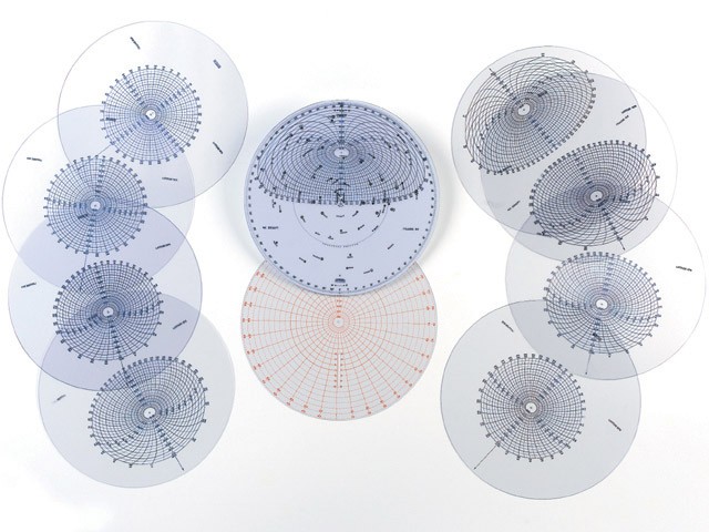
The Star Finder 2102-D is an invaluable tool for celestial navigators to locate and identify, by altitude and azimuth, the 57 stars listed in air and nautical almanacs. It can also be used by amateur star gazers for general star identification.Special diagrams permit rapid check of hour angle and also provide a means of finding altitude and azimuth of unplotted celestial bodies or identification of unplotted bodies from known altitude and azimut. The kit contains a durable black vinyl pouch with velcro closure that holds one star base and 10 plastic templates. Basic instructions are included on the back of the plastic protective sleeve, but a complete instruction guide is available in The Star Finder Book (152), written by David Burch. This book is available separately or in combination with the Star Finder 2102-D (150-152).
- Graphically portrays altitude & azimuth of 57 numbered stars in air & nautical almanacs
- Includes one white plastic star base wheel, 10 clear plastic templates (8 1/2 inch (21.59 cm) diameter), one black vinyl pouch
- Basic instructions on back of protective plastic sleeve
- Lifetime warranty
Specifications
Dimensions (IN):
10.4 x 10.4
Supplier/Publisher:
Weems & Plath
ISBN:
721002001504
Material Options
 Our paper charts are printed on high resolution, heavyweight, water-resistant paper, using state of the art printing technology. The paper and printing process has been certified by NOAA and deemed to be suitable to withstand the rigors of use in the marine environment. FULL SIZED PAPER CHARTS ARE CERTIFIED FOR CARRIAGE ABOARD COMMERCIAL VESSELS |
 Our waterproof charts are printed on a TIP: If you plan to frame or laminate a chart using heat, then do not choose waterproof because the material can melt under heat. FULL SIZED WATERPROOF CHARTS ARE CERTIFIED FOR CARRIAGE ABOARD COMMERCIAL VESSELS |
Size Options |
|
|
|
 These are up-to-date, NOAA charts simply enlarged in size so that the small dimension of the chart is 42”, the long dimension is proportionally enlarged. These charts are printed beyond full size, therefore the scale is not the same as the full size NOAA chart, however the scale bars on the charts are proportionally enlarged in size, and can be used for reference. LARGE FORMAT CHARTS ARE NOT CERTIFIED FOR CARRIAGE ABOARD COMMERCIAL VESSELS |
Other Options |
|
|
|
 Made to help recreational boaters locate themselves on the water. It has been reduced in scale for convenience, but otherwise contains all the information of the full-scale nautical chart. The bar scales have also been reduced, and are accurate when used to measure distances in these BookletCharts. • Professionally printed and staple-bound using high quality, durable paper. • Includes Notices to Mariners • Printed on-demand with the latest data from NOAA BOOKLET CHARTS ARE NOT CERTIFIED FOR CARRIAGE ABOARD COMMERCIAL VESSELS |
 |
This is a unique line of decorative charts prepared by Paradise Cay Publications.
The short side of the chart is always printed at 36" and the long side will vary depending on the chart - please do not order framing prior to receiving the chart. These will memorialize your favorite coastal area in vintage style and we have added to the standard border of the typical NOAA chart to allow for a more professional, frame-ready presentation. DECORATIVE CHARTS ARE NOT CERTIFIED FOR CARRIAGE ABOARD COMMERCIAL VESSELS |


No reviews found
