Cart is empty
Mexico Boating Guide, 3rd edition
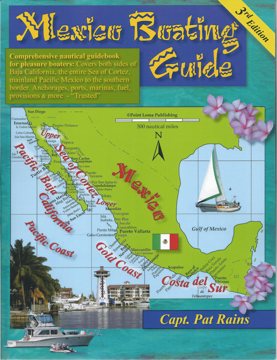
New 3rd edition, Updated Jan 2021. This nautical guidebook for cruising boaters - 312 pages, GPS charts, color photos: written by professional mariners, experienced & active yacht cruisers. Mile by mile, no gaps: Mexico Boating Guide covers the outside of Baja, the entire Sea of Cortez (100s of destinations) to Puerto Vallarta, then continues down the Pacific mainland Gold Coast and Costa del Sur to the new Puerto Chiapas. This nautical guidebook is a Must-have for the Baja Ha Ha. . GPS charts of the tiny cruising anchorages, villages, ports for fuel, provisions, all the marinas, haul-out yards, local services. Rains' 145 new GPS-accurate charts were created on site show anchoring details for tiny bays that are too small to appear with sufficient accuracy on government charts. Rains' 320 photos are jaw-dropping beautiful, but show critical approaches by sea, not just pretty sunsets. No fluffo. Crew List forms, Resource Directory to all marinas, fuel docks, haul-out yards, repair services, provisions, etc. Made in the USA, the new Rains Guide is the accurate authority for boating in Pacific Mexico.
Specifications
Author:
Capt. Pat Rains
Supplier/Publisher:
Point Loma Publishing
Published Date:
2011
ISBN:
9780963847058
Format:
Paperback
Material Options
 Our paper charts are printed on high resolution, heavyweight, water-resistant paper, using state of the art printing technology. The paper and printing process has been certified by NOAA and deemed to be suitable to withstand the rigors of use in the marine environment. FULL SIZED PAPER CHARTS ARE CERTIFIED FOR CARRIAGE ABOARD COMMERCIAL VESSELS |
 Our waterproof charts are printed on a TIP: If you plan to frame or laminate a chart using heat, then do not choose waterproof because the material can melt under heat. FULL SIZED WATERPROOF CHARTS ARE CERTIFIED FOR CARRIAGE ABOARD COMMERCIAL VESSELS |
Size Options |
|
|
|
 These are up-to-date, NOAA charts simply enlarged in size so that the small dimension of the chart is 42”, the long dimension is proportionally enlarged. These charts are printed beyond full size, therefore the scale is not the same as the full size NOAA chart, however the scale bars on the charts are proportionally enlarged in size, and can be used for reference. LARGE FORMAT CHARTS ARE NOT CERTIFIED FOR CARRIAGE ABOARD COMMERCIAL VESSELS |
Other Options |
|
|
|
 Made to help recreational boaters locate themselves on the water. It has been reduced in scale for convenience, but otherwise contains all the information of the full-scale nautical chart. The bar scales have also been reduced, and are accurate when used to measure distances in these BookletCharts. • Professionally printed and staple-bound using high quality, durable paper. • Includes Notices to Mariners • Printed on-demand with the latest data from NOAA BOOKLET CHARTS ARE NOT CERTIFIED FOR CARRIAGE ABOARD COMMERCIAL VESSELS |
 |
This is a unique line of decorative charts prepared by Paradise Cay Publications.
The short side of the chart is always printed at 36" and the long side will vary depending on the chart - please do not order framing prior to receiving the chart. These will memorialize your favorite coastal area in vintage style and we have added to the standard border of the typical NOAA chart to allow for a more professional, frame-ready presentation. DECORATIVE CHARTS ARE NOT CERTIFIED FOR CARRIAGE ABOARD COMMERCIAL VESSELS |


No reviews found
