Cart is empty
Enc Essentials: Getting Started With Electronic Navigational Charts - Book
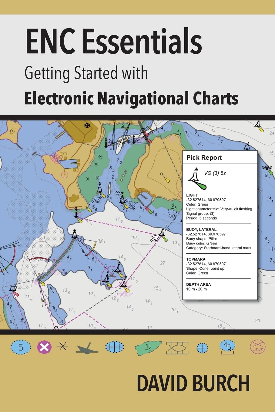
By the end of 2024, electronic navigational charts (ENC) are projected to be the only official NOAA charts, and all traditional paper charts will have been discontinued and NOAA is on schedule to remove the rest as announced. These charts are being replaced by new (reschemed) versions of electronic navigational charts (ENC) that have been in use for over 15 years in ocean shipping, but have not been used much by recreational and other commercial mariners. As of October, 2023, over 60% of paper charts have been permanently removed, and hundreds of new ENC have replaced them. ENC contain much more information than paper charts do, they are easier to keep up to date, and they add notable safety features to navigation-each chart is a dynamic prescription for drawing the chart that knows where all hazards lie, and therefore our electronic chart system (ECS) in use can warn us of their approach. But ENC look different and are structured differently than paper charts. The safe use of ENC requires new knowledge on charts and chart reading. This booklet is a quick guide to how to use these powerful electronic charts, which will very shortly be what we mean when we say "nautical chart."
Specifications
Dimensions (IN):
6 x 0.14 x 9"
Pages:
52 pages
Author:
David Burch
Supplier/Publisher:
STARPATH SCHOOL OF NAVIGATION_
Published Date:
September 25, 2023
ISBN:
9780914025771
Format:
Paperback
Material Options
 Our paper charts are printed on high resolution, heavyweight, water-resistant paper, using state of the art printing technology. The paper and printing process has been certified by NOAA and deemed to be suitable to withstand the rigors of use in the marine environment. FULL SIZED PAPER CHARTS ARE CERTIFIED FOR CARRIAGE ABOARD COMMERCIAL VESSELS |
 Our waterproof charts are printed on a TIP: If you plan to frame or laminate a chart using heat, then do not choose waterproof because the material can melt under heat. FULL SIZED WATERPROOF CHARTS ARE CERTIFIED FOR CARRIAGE ABOARD COMMERCIAL VESSELS |
Size Options |
|
|
|
 These are up-to-date, NOAA charts simply enlarged in size so that the small dimension of the chart is 42”, the long dimension is proportionally enlarged. These charts are printed beyond full size, therefore the scale is not the same as the full size NOAA chart, however the scale bars on the charts are proportionally enlarged in size, and can be used for reference. LARGE FORMAT CHARTS ARE NOT CERTIFIED FOR CARRIAGE ABOARD COMMERCIAL VESSELS |
Other Options |
|
|
|
 Made to help recreational boaters locate themselves on the water. It has been reduced in scale for convenience, but otherwise contains all the information of the full-scale nautical chart. The bar scales have also been reduced, and are accurate when used to measure distances in these BookletCharts. • Professionally printed and staple-bound using high quality, durable paper. • Includes Notices to Mariners • Printed on-demand with the latest data from NOAA BOOKLET CHARTS ARE NOT CERTIFIED FOR CARRIAGE ABOARD COMMERCIAL VESSELS |
 |
This is a unique line of decorative charts prepared by Paradise Cay Publications.
The short side of the chart is always printed at 36" and the long side will vary depending on the chart - please do not order framing prior to receiving the chart. These will memorialize your favorite coastal area in vintage style and we have added to the standard border of the typical NOAA chart to allow for a more professional, frame-ready presentation. DECORATIVE CHARTS ARE NOT CERTIFIED FOR CARRIAGE ABOARD COMMERCIAL VESSELS |


No reviews found
